Park nearby Parque del Cenote
Mexico
Park nearby Parque del Cenote
Parque del Cenote
230, Cancún Méjico
contacts phone
:
+52
Latitude:
21.175768
, Longitude:
-86.8489663
read more
nearest Park
Cenote Park
230, Cancún
Park
read more
710 m
Parque de La Unidad Sm 91
Calle 61 Norte, 91, Cancún
Park
read more
710 m
Unidad Sm 91 Park
Calle 61 Norte, 91, Cancún
Park
read more
715 m
Parque de La Unidad
91
Park
read more
857 m
Parque 232
41 N., 232, Cancún
Park
read more
864 m
Del Charro
Calle 72, Región 232, Benito Juárez, Cancún
Park
read more
925 m
Parque 231
231, Cancún
Park
read more
977 m
Parque de Los Discapacitados
92
Park
read more
990 m
chichen itzá Park
Calle 46 LB, 92, Cancún
Park
read more
990 m
Parque chichen itzá
Calle 46 LB, 92, Cancún
Park
read more
996 m
Jardín de eventos Henequenes
Avenida 20 de Noviembre, 228, Cancún
Park
read more
1.51 km
Parque Super Mza 62
Benito Juárez
Park
read more
1.546 km
Parque Independencia
Av Francisco I. Madero Oriente, SM 72, Benito Juárez, Cancún
Park
read more
1.546 km
Independencia Park
Av Francisco I. Madero Oriente, SM 72, Benito Juárez, Cancún
Park
read more
1.622 km
Parque
Calle 52 Poniente 52-53, 90, Cancún
Park
read more
1.715 km
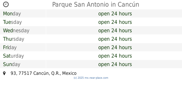
Parque San Antonio
93, Cancún
Park
read more
1.77 km
Parque Recreativo Ostra
27
Park
read more
1.853 km
93 Park
Calle 6 Poniente, SM 93, 93, Cancún
Park
read more
1.853 km
Parque de la 93
Calle 6 Poniente, SM 93, 93, Cancún
Park
read more
1.871 km
Parque La S.m. 27
27
Park
read more
1.884 km
Iglesia De Dios Fuente De Vida
Calle 10 67, 63, Cancún
Park
read more
1.9 km
escuela niños heroes
Calle Erizo 41, 27, Cancún
Park
read more
2.009 km
93 Park
Campaña MZA 72, San Antonio, Benito Juárez, Cancún
Park
read more
2.009 km
Reserva Natural Ombligo Verde
Ixcun 2, 32, Cancún
Park
read more
2.021 km
Parque Deportivo
77517, Calle 103 LB, 93, Cancún
Park
read more
📑
all categories
Accounting
Administrative area level 1
Administrative area level 2
Airport
Amusement park
Aquarium
Art gallery
Atm
Bakery
Bank
Bar
Beauty salon
Bicycle store
Book store
Bowling alley
Bus station
Cafe
Campground
Car dealer
Car rental
Car repair
Car wash
Casino
Cemetery
Church
City hall
Clothing store
Colloquial area
Convenience store
Courthouse
Dentist
Department store
Doctor
Electrician
Electronics store
Embassy
Finance
Fire station
Florist
Food
Funeral home
Furniture store
Gas station
General contractor
Grocery or supermarket
Gym
Hair care
Hardware store
Health
Hindu Temple
Home goods store
Hospital
Insurance agency
Intersection
Jewelry store
Laundry
Lawyer
Library
Light rail station
Liquor store
Local government office
Locality
Locksmith
Lodging
Meal delivery
Meal takeaway
Mosque
Movie rental
Movie theater
Moving company
Museum
Natural feature
Neighborhood
Night club
Painter
Park
Parking
Pet store
Pharmacy
Physiotherapist
Place of worship
Plumber
Point of interest
Police
Political
Post office
Premise
Real estate agency
Restaurant
Roofing contractor
Route
Rv park, camping
School
Shoe store
Shopping mall
Spa
Stadium
Storage
Store
Subpremise
Subway station
Supermarket
Synagogue
Taxi stand
Train station
Transit station
Travel agency
University
Veterinary care
Zoo
administrative area level 3
sublocality level 1
↑