Park nearby Jardín de La Cultura
Mexico
Park nearby Jardín de La Cultura
Jardín de La Cultura
Centro Méjico
contacts phone
:
+52
Latitude:
21.5029768
, Longitude:
-104.8957249
read more
nearest Park
12 m
Plaza Del Maestro
Veracruz Sur 270, Centro, Tepic
Park
read more
389 m
La Loma
Mazatlan - Tepic, Fray Junípero Serra, Tepic
Park
read more
392 m
Parque La Loma
Calle Puebla 239, Centro, Tepic
Park
read more
510 m
Nodo Vial
Boulevard Tepic-Xalisco 521, Morelos, Tepic
Park
read more
510 m
Monumento Nodo Vial Veracruz
Boulevard Tepic-Xalisco 521, Morelos, Tepic
Park
read more
546 m
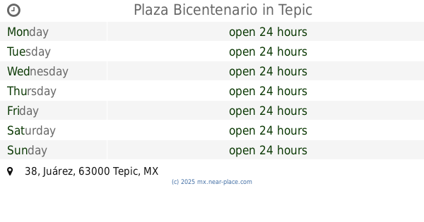
Plaza Bicentenario
Juárez 38, Centro, Tepic
Park
read more
553 m
Parque La Cruz
Boulevard Tepic-Xalisco 521A, Caja de Agua, Tepic
Park
read more
576 m
Jardín Ex-convento de La Cruz
Centro
Park
read more
755 m
Jardín Electricistas
Electricistas
Park
read more
784 m
Electricistas Garden
Electricistas, Tepic
Park
read more
784 m
Jardín Electricistas
Electricistas, Tepic
Park
read more
846 m
Parque de la Madre
Avenida Ignacio Allende Poniente, Centro, Tepic
Park
read more
846 m
Madre Park
Avenida Ignacio Allende Poniente, Centro, Tepic
Park
read more
901 m
Parque Morelos
Sierra de San Juan 38, Jardines de la Cruz, Tepic
Park
read more
947 m
Parque La Alameda de Tepic
63109, Paseo de La Alameda 8, Estadios, Tepic
Park
read more
947 m
La Alameda de Tepic Park
63109, Paseo de La Alameda 8, Estadios, Tepic
Park
read more
955 m
Plazuela Hidalgo
Padre Enrique Mejía 111, Centro, Tepic
Park
read more
970 m
Parque Deportivo Morelos
General Rafael Buelna 103, Morelos, Tepic
Park
read more
977 m
Plazuela Hidalgo
Centro
Park
read more
988 m
Centro De Mediacion
Quetzales 23, INFONAVIT el Tecolote, Tepic
Park
read more
1.016 km
Alameda de Tepic
Avenida Ignacio Allende Poniente 399-434, Centro, Tepic
Park
read more
1.059 km
Plaza Tepic
Centro, Tepic
Park
read more
1.069 km
Zanjon de la Esperanza
Zanjón de La Esperanza, Estadios, Tepic
Park
read more
1.069 km
Zanjón de La Esperanza
Estadios
Park
read more
1.074 km
Fuente Juan Escutia
Centro, Tepic
Park
read more
📑
all categories
Accounting
Administrative area level 1
Administrative area level 2
Airport
Amusement park
Aquarium
Art gallery
Atm
Bakery
Bank
Bar
Beauty salon
Bicycle store
Book store
Bowling alley
Bus station
Cafe
Campground
Car dealer
Car rental
Car repair
Car wash
Casino
Cemetery
Church
City hall
Clothing store
Colloquial area
Convenience store
Courthouse
Dentist
Department store
Doctor
Electrician
Electronics store
Embassy
Finance
Fire station
Florist
Food
Funeral home
Furniture store
Gas station
General contractor
Grocery or supermarket
Gym
Hair care
Hardware store
Health
Hindu Temple
Home goods store
Hospital
Insurance agency
Intersection
Jewelry store
Laundry
Lawyer
Library
Light rail station
Liquor store
Local government office
Locality
Locksmith
Lodging
Meal delivery
Meal takeaway
Mosque
Movie rental
Movie theater
Moving company
Museum
Natural feature
Neighborhood
Night club
Painter
Park
Parking
Pet store
Pharmacy
Physiotherapist
Place of worship
Plumber
Point of interest
Police
Political
Post office
Premise
Real estate agency
Restaurant
Roofing contractor
Route
Rv park, camping
School
Shoe store
Shopping mall
Spa
Stadium
Storage
Store
Subpremise
Subway station
Supermarket
Synagogue
Taxi stand
Train station
Transit station
Travel agency
University
Veterinary care
Zoo
administrative area level 3
sublocality level 1
↑